
IMMAGINI RELATIVE AI MIEI MESSAGGI
per il FORUM FILATELIA e FRANCOBOLLI pagina 109
FORUM CONTINUA: 109 qui parliamo delle EX "DISPUTE" fra USA e diverse nazioni sul possesso di alcune isole del Pacifico e dei Caraibi. Questa pagina completa i Territori ESTERNI degli USA di pagina 69.
In fondo mettiamo, in inglese, una lista ragionata di tutte le isole che furono "prese" a seguito dell'emanazione del Guano Act degli Stai Uniti e delle successive dispute.
Ma adesso voglio riportare una notizia dal Corriere della Sera del 13 febbraio 2006:
fa piacere sapere che, in questa pagina, avevamo già dato la notizia da diversi giorni (vedi sotto)
Comunque il referendum è fallito nel senso che non si sono raggiunti i 2/3 dei voti necessari per diventare uno dei più piccoli Stati del mondo. Ecco la notizia da un giornale Australiano:
![]() NOVITA': Ecco un mio
articolo sulle Tokelau apparso su Il Collezionista nel dicembre 2010:
NOVITA': Ecco un mio
articolo sulle Tokelau apparso su Il Collezionista nel dicembre 2010:
clicca: "La strana storia dei francobolli di Tokelau" L'articolo è stato montato qui in gennaio 2011 in formato pdf.
|
Last Updated 16/02/2006,
19:19:13
|
Avendo ricevuto il "summary" di queste ex-dispute in inglese, per rapidità lo trascrivo pari pari, ma penso che il testo sia assolutamente comprensibile.
Per ognuno dei 7 gruppi in cui sono state raggruppate le isole che erano in disputa, metto un reperto filatelico o il link alle pagine precedenti in cui abbiamo postato qualcosa.
In the twentieth century the United States has disputed with other nations the status of certain islands or atolls. Five (5) were in the Caribbean; twenty-five (25), in the Pacific. For purposes of discussion, one may divide these thirty (30) islands or atolls into seven groups.
(1) The
status of the islands of Canton (Kanton), Enderbury, Hull (Orona), Birnie,
Gardner (Nikumaroro), Phoenix (Rawaki), Sydney (Manra), McKean, Christmas (Kiritimati),
Caroline, Starbuck, Malden, Flint and Vostok:
On September 20, 1979, representatives of the United States and Kiribati met in
Tarawa Atoll in the northern district of the Gilbert Islands. There they signed
a treaty of friendship on behalf of their two nations, an agreement which many
refer to as the Treaty of Tarawa of 1979. Under that treaty the United States
recognized Kiribati's sovereignty over these fourteen islands. This treaty
entered into force on September 23, 1983.
Per le isole del punto 1) vedi la pagina 99 che è specifica per le isole Kiribati (ex Gilbert). Vai a pagina 99.
(2) The status of the United States' claim to certain atolls
in the northern Cook Islands, Danger (Pukapuka), Manahiki, Penrhyn and
Rakahanga:
On June 11, 1980, the United States and the Cook Islands signed in Rarotonga a
treaty of friendship to delimit maritime boundaries. By the terms of this treaty
the United States renounced its claim to these four atolls and acknowledged the
sovereignty of the Cook Islands over them. This treaty entered into force on
September 8, 1983. Since August 4, 1965, the Cook Islands have been a
state in free association with New Zealand. This relationship resembles very
closely that which the Marshall Islands and the Federated States of Micronesia
have enjoyed with the United States since October 21, 1986,and November 3, 1986,
respectively.

mappa dell Cook islands Nord e Sud
Un buon link che mostra molte immagini satellitari delle isole Cook è al link:
http://homepage.ntlworld.com/jwroberts/aerials.html
NEWS
![]() Vale la pena mettere anche
qui il link ad un mio articolo apparso su Il Collezionista nel giugno 2012.
Parla del grande navigatore James Cook e delle isole Cook:
Vale la pena mettere anche
qui il link ad un mio articolo apparso su Il Collezionista nel giugno 2012.
Parla del grande navigatore James Cook e delle isole Cook:
L'articolo ha il titolo "Sulla rotta di Cook". Articolo montato qui a fine luglio in formato pdf. Nel frattempo ho trovato almeno 1 cartolina ed una cover con annullo di tutte le isole Cook.
Non tutte le ho montate qui, ma se avete necessità vi mando la relativa immagine.
Stiamo parlando delle Cook del Nord:

Pukapuka* (o Danger island) ubicata 10°53′S 165°51′W nelle Cook del Nord

postmark di Danger* island N.Z.o Pukapuka
(annullo di arrivo ad Apia Western Samoa, annullo Danger island della Nuova Zelanda)
Finalmente dopo lunghe ricerche, con un po' di fortuna ho trovato una cover del 1954 con annullo di Pukapuka a soli 2 Euro! Eccola:

Cook islands del Nord: Pukapuka detta anche Danger island
Ho trovato poi la sola immagine di una cover del 1952 con postmark: Danger island":

Danger* island cover del 1952
Ma c'è una Pukapuka island anche nelle Tuamotu e questa cover ha l'annullo su bolli della Polinesia francese. Però l'esatta dizione è Puka-Puka ed è ubicato 17° 40′47″S 149°24′25″W:

Puka-Puka atoll nelle Tuamotu: annullo del villaggio principale di Te One Mahina che ha 117 abitanti su un totale di 197:

vale la pena vedere un'immagine dall'alto di Puka-Puka (isole Tuamotu nella Polinesia francese)
Passiamo ora all' atollo di Manihiki:

atollo di Manihiki o Manahiki detto "l'atollo delle perle"

Manihiki postmark 1933

QSL di Penrhyn atoll 1979 ( Penrhyn è noto anche come Tongareva atoll) a 848 miglia NNE da Rarotonga

frammento di lettera spedita da Penrhyn in Canada e arrivata a destinazione durante uno sciopero postale

francobollo di Penrhyn in sovrastampa su Cook island

1977 postmark delle Nord Cook islands: Penrhyn

Rakahanga cover 1939
ora di seguito tre nuove e rare postcard:

Suwarrow island nelle Northern Cook islands

Nassau island nelle Northern Cook islands
Ora due isole delle Cook del Sud:

Palmerston atoll nelle Cook del sud

Mangaia island South Cook: QSL card*
A 100 km da Aitutaki c'è l'atollo di Manuae 19°43′1″S 158°57′W composto da sue isole. Non è da confondersi con l'omonima isola nell'arcipelago della Società (Tahiti tanto per intenderci). Ecco l'immagine aerea di Mauae nelle Cook:

sono solo due le isole che compongono l'atollo di Manaue nelle Cook
Per l'osservazione scientifica dell'eclisse solare del 31 maggio del 1965 fu emesso un francobollo da parte dell'amministrazione postale delle isole Cook. Fu anche predisposto un annullo speciale di Manuae:

scarsa FDC del 31 maggio 1965 quando fu aperto un ufficio postale a Manaue per l'eclissi solare. Fu emesso anche un francobollo che è sulla destra.
Sul retro è visibile l'annullo d'arrivo a del 30 agosto 1965 a Bamrauli in India (Uttar Pradesh)
All'epoca nell'atollo di Manuae si trovava solo uno sparuto gruppo di lavoratori del copra. Ma data la favorevole posizione geografica per assistere all'eclissi totale del sole, ben 85 astronomi di tutto il mondo vi si recarono il 30 maggio del 1965. Un ufficio postale temporaneo fu aperto in quell'isola.
Chi volesse approfondire vada al link: http://cookislandslibraryandmuseum.blogspot.com/2010/07/solar-eclipse-at-manuae-in-1965.html
E' lampante che questa cover non può mancare in una collezione di "Filatelia delle isole deserte"!!
Continuiamo con
le isole in "disputa":
(3) The status of the United States' claim to certain atolls in the Union (Tokelau)
Islands, Atafu, Fafaofu (anche Falaofo o Fakaofo) and Nukunonu:
On December 2, 1980, the United States and New Zealand signed in Atafu Atoll
itself a treaty to delimit the maritime boundary between the United States and
Tokelau, a New Zealand territory. As a result of this treaty, the United States
relinquished its claim to these three atolls and acknowledged New Zealand's
sovereignty over them on Tokelau's behalf. This treaty entered into force on
September 3, 1983.
Come riportato ad inizio pagina nel 2006 un referendum doveva decidere se le Tokelau dovevano restare una dipendenza della Nuova Zelanda oppure essere completamente indipendente. Tokelau è lo Stato più piccolo al mondo dopo il Vaticano. Conta 1.500 abitanti che si chiamano "Tokelauiani."

Tokelau: mappa su cover da Nukunonu in Australia

isola di Nokunonu

Nukunonu postmark quando le Tokelau si chiamavano Union islands

cover da Atafu a Samoa 1948

postmark di Atafu on piece*

la seconda isola delle Tokelau: Atafu

cover da Fakaofo alle Figi

la terza delle isole Tokelau: Fakaofo o Falaofo o Fafaofu
Prima che avessero propri francobolli le Tokelau usavano dentelli delle Western Samoa, con tre annulli differenti per i tre atolli e la dicitura "Union islands". Ecco una interessante cover del 1936:

1936: cover con annulli delle Union islands*
Tokelau Forerunner, Union Islands cancel date stamp on Western Samoa stamps, 1936. Three 1 penny postmarked from the three post offices in the Union Islands, Nukunono, Sep. 22, 1936, Atafu, Sep. 30, 1936 and Fakaofo, Oct. 2, 1936 on pre-printed unaddressed On His Majesty's Service envelope.
Altre due isole interessanti e vicino alle Tokelau sono Swains island è Rose island: vedi cover e postcard a pagina 44d.
Tokelau, a former
British protectorate, became a territory of New Zealand in 1925. The territory,
located north of Samoa, includes the three Polynesian atolls of Atafu, Nukunonu
and Falaofo. If the result is in favour of self-determination, the New Zealand
parliament will repeal the Tokelau Act of 1948 and the two governments will sign
a Treaty of Free Association with Tokelau no longer being a colony.
(4) The
status of the United States' claim to certain atolls in the Ellice Islands,
Funafuti, Nukefetau, Nukulaelae and Nurakita (Niulakita):
On February 7, 1979, diplomats representing the United States and Tuvalu met in
Funafuti Atoll itself and signed a treaty of friendship. By this treaty the
United States ended its claim to these four atolls. This treaty entered into
force on September 23, 1983.
Per le isole ex- Ellice ora Tuvalu vedi a pagina 99.
(5)
The United States' claim to Quita Sueno Bank, Roncador Cay and Serrana Bank:
To the north of Panama and east of Nicaragua, this cluster of islands was the
subject of a treaty which the United States and Colombia signed in Bogota on
September 8, 1972. Under its terms the United States has recognized Colombia's
sovereignty over these islands. This treaty entered into force on September 17,
1981.
Abbiamo pochi reperti sul punto 5, uno è realtivo a Serranilla Bank a pagina 69.
(6)
The United States' former sovereignty over the Swan Islands:
In relative isolation, the Swan Islands lie in the western Caribbean,
ninety-five miles north of the coast of Honduras and three hundred twenty miles
west of Jamaica. They consist of Great Swan and Little Swan Islands, of which
neither has any dimension of more than about two miles. In 1863 the area was
certified as islands appertaining to the United States under the Guano Islands
Act of August 18, 1856 (Title 48, U.S. Code, sections 1411-19), and guano
operations were carried on there for many years.
Per Swan island vedi a pagina 69 e anche l'articolo: Le isole del Guano Act. C.C. novembre 2013
The United States' later interests in the Swan Islands involved agricultural
production in coconut plantations and aids to navigation and communications,
resulting in continued United States occupation and use of the islands. In San
Pedro Sula, Honduras, on November 22,1971, American and Honduran representatives
signed a treaty by which the United States recognized Honduras' long-standing
claim to sovereignty over the Swan Islands. The treaty entered into force on
September 1, 1972.
(7)
The United States' former administration of the Corn Islands:
Made up of Great Corn and Little Corn Islands, the Corn Islands lie about thirty
miles off the coast of Nicaragua. They never were a U.S. insular area, that is,
under the sovereignty of the United States, but were leased from Nicaragua for a
period of ninety-nine years under the Convention of Washington, D.C., of August
5, 1914. The terms of the lease made the Corn Islands subject exclusively
to American laws and administration. However, with the United States'
acquiescence, the Government of Nicaragua directed the islands' local
administration. The United States' right to the actual or potential use of the
islands remained unimpaired until April 25, 1971, when the lease was officially
terminated and the Convention of Managua of July 14, 1970, entered into force.
Per Corn island vedi a pagina 69, qui metto una rara QSL della più piccola delle Corn island:
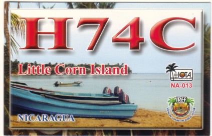
Corn islands: Little Corn island QSL card 2003 (ora con Corn island si chiama Islas del Maiz)

retro della stessa QSL card: Little Corn island
REMAINING U.S. CLAIMS:
None.
Che io sappia alla data non ci sono Territori in "disputa" con gli USA, se non alcune questioni su confini con il Canada e qualche altro "minor", tipo acque territoriali...
ALTRE ISOLE "IN DISPUTA" O CHE FURONO CONTESE DA DUE O PIU' NAZIONI
Spostiamoci nel Mar Rosso e precisamente nello Yemen. Lì esiste l'arcipelago delle Kamaran con isola principale Kamaran island. E' un posto aperto da poco al turismo. E' comunque un'isola "estrema" ed ha anche una sua interessante valenza filatelica.
Essa è stata posseduta dai portoghesi, poi dall'impero ottomano, occupata poi dai Britannici che la considerarono una parte di Aden, nonostante le rivendicazioni delle varie fazioni che governarono lo Yemen. Infatti alla fine della prima guerra mondiale il suo "status" rimase ambiguo e solo con l'abbandono degli inglesi di Aden, ritrovò una sua logica appartenenza . Fu quindi sotto la giurisdizione dello Yemen: prima come Yemen del Sud, poi del Nord ed infine come Yemen "Unito" o Repubblica dello Yemen.
Ecco i dati postali:
Kamaran Island had an Ottoman post office until 1915 and had a sub-post office of Aden beginning in 1924. From 1967, it was a postal territory of South Yemen, from 1972, of the Yemen Arab Republic, and, from 1990, the Republic of Yemen.
Traduzione: Kamaran ebbe un ufficio postale dell'impero Ottomano sino al 1915 e un sub-ufficio dipendente da Aden nel 1924. Dal 1967 fu territorio postale dello Yemen del Sud e dal 1972 dello Yemen Arab Republic (l'altra fazione), ed infine dal 1990 della Repubblica dello Yemen.
Ho trovato anche una bella cover con annullo di Kamaran su francobolli di Aden:

1953 Kamaran island cover* con annullo locale su bolli dell'Aden

alcune Kamaran* islands nel Mar Rosso

arcipelago Kamaran mappa con la costa dello Yemen sulla destra

annullo di arrivo a Kamaran del 9 settembre 1946

finalmente ho trovato una postcard. Ecco nel 1920 la nave Enterprise alla fonda a Kamaran
Ora sarebbe interessante trovare un annullo attuale ed anche un vecchio annullo usato dall'impero ottomano...
Veniamo al Guano Act, ovvero a quella legge americana che permetteva agli avventurieri di diventare proprietari e sfruttatori delle risorse di isole deserte purché avessero giacimenti di guano. La sovranità di queste isole passava agli USA. Un libro di Jimmy M. Skaggs del 1994 racconta la corsa all'espansione americana di oltremare, grazie alla promulgazione di questa legge. Ma che fine hanno fatto tutte queste isole?

Corsa al guano... un po' come la corsa all'oro
Un signore americano si è messo a fare le pulci all'elenco delle isole nominate nel libro. Poi ci racconta che fine hanno fatto e chi è l'attuale Stato che ne ha la sovranità.
Guano islands: here goes.
I don't have a scanner, so I can't give you the whole appendix. It's pages
230-236. The Great Guano Rush Jimmy M. Skaggs St. Martin's Press, New York,
1994.
There are 103 total entries for islands, rocks, and keys.
After sitting on my couch with my green accountant's eyeshade pulled low over my
eyes for hours, trying to make the numbers work, here's my final answer:
59 entries are in no way a Guano Island, because:
a. they are duplicate entries for the same island, for lots of different reasons
(duplicate claims, different names, etc);
b. they were claimed, but never bonded, and thus never appeared on any guano
islands list from the federales;
c. they were/are nonexistent.
2 entries are not bonded, but interesting:
French Frigate Shoals (one of the current Northwest Hawaiian Islands) is listed
as claimed, but without a date (very unusual); anyway, it was never bonded.
Hull (Orona) is the only entry listed as never even having been claimed under
the Guano Act. Maybe Skaggs included it on the list because it was one of the
islands which the USA quitclaimed to Kiribati, or maybe because it somehow crept
onto some version of a list somewhere along the way.
So, with those 61 out of the way, that leaves 42 which, by my count, were bonded
under the Guano Act, do actually exist, and are unduplicated.
3 conceded to Mexico 1894: Alacrans, Arenas, Western Triangle Keys
1 conceded to Venezuela 1855: Aves
2 conceded to UK (now Jamaica) 1862,1878: Morant, Pedro
2 conceded to UK (now Kiribati) 1888, 1892: Washington (aka
Teraina), Fanning (aka America, aka Tabueran)
1 conceded to UK (now Cook Islands) 1888: Nassau
1 conceded to UK (now Tokelau, NZ) 1889: Atafu (aka Duke of York)
So there are 10 which you could maybe in some sense call Guano islands, but I
wouldn't because I'm not even sure they ever made it onto any version of the
list; basically somebody filed a bond on someone else's island is one way to
look at it. But there they are; you be the judge.
Now, the remaining 32, baby, those are the ones which get certain people's blood
circulating a little bit quicker.
Richard Milhous Nixon dumped 4 by treaties.
3 to Colombia 1972: Quito Sueno, Roncador, Serrana
1 to Honduras 1972: Swans
Jimmy Carter unloaded 18 by treaties:
13 to Kiribati 1979: Barren (aka Starbuck), Birnies, Caroline, Christmas,
Enderbury, Flint, Gardner, Maldens, Mary's,
McKean, Phoenix, Sydney, Vostok.
**Note: Hull (Orona) not counted here -- see above).
4 to Cook Islands 1980: Pukapuka (aka Danger(ous)), Manahiki (aka Humphreys),
Tongareva (aka Penrhyn), Rakahanga (aka Rierson) 1 to Tuvalu 1979: Duke of
Clarence (aka Nukufetau)
So, there's 22 of the remaining 32 gone from 1972-1980.
8 of the other 10 are still all red-white-and-blue.
1. Baker
2. Howland
3. Jarvis
4. Johnston
5. Kingman
6. Navassa
7. Palmyra, also considered as thru the annexation of Hawaii
8. Swains (attached to American Samoa 1925)
9. Seranilla and
10. Petrel (aka Bajo Nuevo) are both in limbo between Colombia and the USA
So (with apologies to Tony Kornheiser)
THAT'S IT -- THAT'S THE LIST!
La risposta di geoh88 era legata a
questa richiesta che era corredata da qualche link utile:
--- In BoundaryPoint@yahoogroups.com,
"raedwulf16" <raedwulf16@y...>
wrote:
Some of the territories administered by the USA were acquired under
the Guano Act.I have read the act,and I have seen numerous references;
however,I can not seem to find a list of ALL the islands claimed by the USA
under the act .I understand that some of these claims have been
reliquished or allowed to lapse after the need
for droppings
declined.Does anyone know where I can get a complete
list?
Thanks! http://www.u-s-history.com/pages/h1047.html
http://www.u-s-history.com/pages/h1049.html
http://geography.about.com/od/politicalgeography/a/guanoisland.htm
http://en.wikipedia.org/wiki/Guano_Islands_Act
http://www.425dxn.org/dc3mf/navassa.html
http://www.photolib.noaa.gov/historic/c&gs/theb0078.htm
http://novomilenio.inf.br/ano97/lighth1.jpg
NOTA BENE: se interrogate, con il nome delle varie isole del libro
sul Guano Act, il motore di ricerca a fondo pagina, vi verranno
segnalate le pagine di questo sito che mostrano postcard, cover e
francobolli del 95% di esse. Penso che la maggior parte dei reperti siano a
pagina 69 o qui.
Bene, ppozzo68 si è dato la briga di fare la ricerca per vedere quali "disputed islands" citate nel libro non hanno ancora avuto un riscontro nel nostro sito. Ecco cosa dice:
Grazie Paolo, hai fatto un gran lavoro! Vediamo cosa mi ricordo:
- Alacrans, Arenas e Western Triangle Keys, in disputa con il Messico sono messicane da metà 1800 (comunque vanno cercati i reperti);
- Morant, Pedro date alla Giamaica (vanno cercati i reperti);
Quito Sueno e Roncador in disputa con la Colombia sono ora colombiane (vanno cercati i reperti), Quito Sueno bank e Roncador Cay sono citati a pagina 69 con tanto di mappa insieme a Serrana, ho fatto delle immersioni lì vicino alcuni anni fa;
- Swans è Swan (ora dell'Honduras) è ed citata a pagina 69 con reperti;
- Birnies (è Birnie), Maldens (è Malden) sono nelle isole Kiribati, sono citate a pagina 99 e vi sono mostrati dei francobolli che le rappresentano (vanno comunque cercati dei reperti con annulli locali sempre
che esistano): Birnie fu visitata dalla nave U.S. Bushnell nel 1939 e esistono cover con il nome dell'isola fra le barre dell'annullo killer bar.
- Malden ha una bella cover a pagina 99
- Mary's island è certamente Canton/Abariringa nelle Kiribati. Di Canton abbiamo vari reperti a pagina 69;
- Tongareva è Penrhyn island ed è in questa pagina;
- Serenilla è Serranilla ed è "insieme" a Serrana bank a pagina 69.
Quindi direi che mancano reperti di 5 isole (quelle segnate qui in rosso) e che sono dispute concluse già prima del 1900.
Vediamo comunque cosa riusciremo a trovare. Poalo, sappi che hai vinto una cover "misteriosa" che ho già provveduto a spedirti!
ciao fabiov!!

pagina a cui aggiungeremo altre isole EXTREME "in disputa o che furono contese", quando avremo trovato nuove informazioni
------------------- °°°°°°°°°°°°°° --------------------
Mi scuso per eventuali imprecisioni, infatti, per risparmiare tempo, mi sono affidato solo alla mia memoria. Per certo posso fornire le fonti - sicuramente più attendibili di me - da cui ho tratto le varie informazioni. Se volete approfondire i vari argomenti, contattatemi.
P.S. Su questo sito potete vedere immagini, articoli e approfondimenti ai temi discussi nei miei messaggi per il forum Filatelia e Francobolli. Chi fosse interessato ai bolli della seconda guerra mondiale, a quelli dei prigionieri di guerra o di propaganda psicologica, alla resistenza, nonché alla storia contemporanea, incluse le missioni di pace italiane nel mondo e quelle scientifiche al polo sud, può visitare le oltre 500 pagine, in italiano ed in inglese, del sito, cliccando semplicemente sul tasto "Iniziale" qui sotto. Gli altri tasti aiutano la navigazione all'interno di questa sezione "le storie dietro i francobolli" e "Curiosità filateliche". Precisamente: il sommario riporta gli argomenti trattati in ogni pagina; i tasti dall' 1 al 108 aiutano ad accedere direttamente alle prime xx pagine (12 per volta) ed infine c'è il link alla corrispondente pagina/pagine del Forum di F&F in cui lo stesso "topic" è stato discusso.N.B. Le schermate sono state ottimizzate per video a 17 pollici e collegamento ADSL, per cui molte righe ed immagini potrebbero risultare distorte, spostate o lente a scaricarsi, su altri schermi o computer con vecchi modem. Nel caso scrivetemi che provvederò a fare migliorie specifiche.
 |
 |
|
|


