IMMAGINI RELATIVE AI MIEI MESSAGGI
per il FORUM FILATELIA e FRANCOBOLLI pagina 69
1a PARTE: USA
FORUM CONTINUA 69 qui ricapitoliamo quelli che sono I TERRITORI ESTERNI degli Stati UNITI. Poi introduciamo quelli della Francia e quelli Britannici e via via quelli Spagnoli, Danesi, Norvegesi, Australiani, Neozelandesi, Olandesi (?). Parliamo cioè di "geografia politica".
(Siccome la pagina è diventata troppo piena, i nostri discorsi continueranno a pagina 69aa con gli APO e FPO degli USA, poi con la seconda parte a pagina 69a (Francia, Norvegia, Spagna) e con la terza a pagina 69b (U.K.), mentre altri argomenti saranno visti a pagina 70. A fondo pagina ci sono comunque i vari bottoni.)
Un tempo si collezionavano i francobolli delle colonie: chi faceva l'area italiana, chi quella francese, chi quella inglese etc. poi lentamente le colonie sparirono in quanto quasi tutte diventarono Paesi indipendenti. Allora iniziò la collezione del Commonwealth e dei territori francesi d'oltremare. Per l'Italia si passò a collezionare la Somalia come amministrazione fiduciaria e così per altre Nazioni.
Ma oggi, se uno volesse collezionare i territori che in qualche modo sono legati alla regina Elisabetta II o quegli Stati/territori che hanno un rapporto privilegiato con gli Stati Uniti, in quanto i loro cittadini godono praticamente degli stessi diritti di chi nasce negli USA, che cosa dovrebbe raccogliere?
Ho fatto un elenco di tutti quei territori che sono legati a filo doppio con una certa Nazione, pur essendo LONTANI anche migliaia di chilometri dalla madre patria.
Ho chiamato questi TERRITORI: TERRITORI ESTERNI o EXTERNAL TERRITORIES. Una definizione di comodo che dà l'idea che non sono territori SOVRANI e che la sovranità è esercitata da un Paese geograficamente lontano. Ciascuno di questi Territori ha un rapporto particolare con la "mainland". Non ci si può addentrare in tutte le differenze fra questi tipi di legami, perché ci sono anche questioni complesse inerenti il diritto internazionale. Nell'elenco che ho preparato ci sono anche alcune piccole isolette che sono ancora soggette a dispute fra un paio o più nazioni.
E siccome noi siamo curiosi, cercheremo sempre di avere dei reperti FILATELICI per ciascuno di questi EXTERNAL TERRITORIES.
Nelle pagine precedenti (vedi: SOMMARIO) ho inserito buste ed annulli o cartoline di molti di questi posti, soprattutto se si si riferiscono agli Stati Uniti. Ora intendo mettere un po' d'ordine e quindi partendo da questa pagina potrete trovare tutto ciò che nel tempo abbiamo sparso in giro e trovare i link diretti alle cover o agli annulli..
Il progetto è però ambizioso, nel senso che non avendo molto tempo, solo di tanto in tanto aggiornerò questa pagina.
Tanto più ci saranno lettori interessati e vostri contributi, tanto più lavorerò su questo topic che è specifico per gli amanti della "geografia politica."
Per iniziare raduno qui una prima serie di elenchi e qualche pagina in inglese che possono darvi l'idea di di che cosa stiamo parlando.
Più avanti tradurrò le cose in inglese che possono essere di interesse generale.
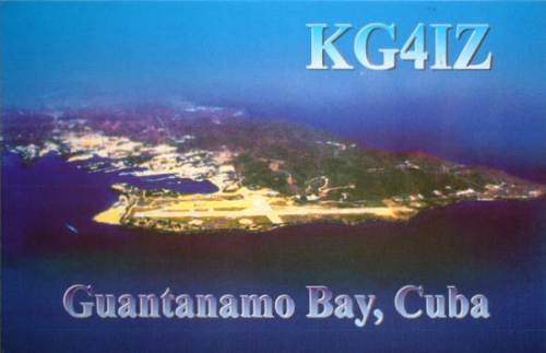
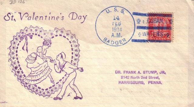
In fondo a questa pagina trovate dei dati riferiti a GUANTANAMO, la base americana in territorio cubano. E' un territorio legato agli USA da un trattato di "NOLEGGIO" molto particolare: vale la pena leggere le informazioni che ho riportato per saperne di più. Esistono molti annulli di navi che stazionando nella "Baia di Guantanamo" hanno annullato delle cover con quel nome, una di queste è a fondo pagina.
Due parole sul "GUANO ACT". negli USA intorno all'anno 1856 fu promulgato il Guano Act. Questa legge permetteva a chiunque prendesse possesso di un'isola deserta contenente dei deposti di guano, di diventarne proprietario ed averne il diritto di sfruttamento, mentre la sovranità dell'isola era degli Stati Uniti. Si scatenò una vera caccia alle isole sperdute... Vi ricordate la storia del "gambero nero" dell'isola di Clipperton? Quell'isola fu contesa fra Francia, Messico e Stati Uniti, proprio in funzione della presenza di guano. I francobolli locali furono emessi da una società di San Francisco che sfruttava i giacimenti di guano. Il personale era messicano. Poi, allo scoppio della guerra civile in Messico e della prima guerra mondiale, l'isola fu dimenticata e lasciata senza rifornimenti. Praticamente morirono tutti o quasi... Ora l'isola è "assegnata" alla Francia.
Per i territori POCO NOTI sarebbe bello raccogliere annulli - o francobolli locali se esistenti- e magari le cartoline di isole ESTREME o di basi Antartiche.
Ecco intanto l'elenco completo dei territori americani che fanno parte integrante degli Stati Uniti ma sono lontani dalla mainland...
The
territory of the United States of America consists of:
1. the 50 states of the Union
2. the District of Columbia
3. one Incorporated Territory: Palmyra (vedi pagina
3 e pagina 98)
American
law is fully applicable to these three.
In addition, the USA possesses several other places:
five United States Territories:
1. Puerto
Rico (vedi in questa pagina
un annullo)
2. Guam (vedi in questa pagina una postcard ed un
annullo)
3. US
Virgin Islands (vedi una postcard ed un annullo a
pagina 79)
4. American Samoa (vedi postcard ed annullo a pagina
81)
5. Northern Marianas arcipelago
(vedi in questa pagina
una QSL card e precancel e poi anche a
pagina 101 (altre informazioni al http://www.postmark-micronesia.pwp.blueyonder.co.uk/cnmi.htm )
ma
queste ISOLE,
ARCIPELAGHI, ATOLLI E REEF minori:
6. Wake island e Wilkes island (vedi in questa pagina
una cover ed un annullo ed una postcard)
7. Midway islands (vedi in questa pagina
un annullo ed una postcard QSL)
8. Baker island (vedi pagina
3 una cover e un annullo)
9. Howland island (una postcard QSL in questa pagina,
una cover a metà di pagina
64 ed un'altra a pagina 3.)
10. Jarvis island ( vedi
in questa pagina due postcard, una QSL card ed due cover)
11. Johnston reef (vedi pagina
3 una cover, annullo e link a postcard)
12. Kingman reef, talora scritto erroneamente
"Kingsmans reef" ( vedi
in questa pagina una postcard, una QSL
card e due cover)
13. Navassa island (vedi in questa pagina una postcard
QSL)
Various
of these are styled unincorporated territories (both organized and
unorganized),
commonwealths, or possessions. They have a variety of legal
statuses,
some highly individualized. See
http://groups.yahoo.com/group/BoundaryPoint/message/14346
for
a discussion of some of the complexities:
"For
instance: Guam is an organized but unincorporated territory, while Palmyra is an unorganized but incorporated Territory. Puerto Rico is a
possession, but neither a territory nor a Territory. It is a Commonwealth, but so is Kentucky,
which it is a state. Persons born in US possessions are US citizens, except those in American Samoa, who are US nationals, but not US
citizens. Goods brought to the rest of the USA from the Virgin Islands are subject to customs
duties, but not those from Puerto Rico. The CIA and State Department claim that the Republic of Palau is an independent and sovereign nation, but "in free
association" with the USA. The address of the office of the President (chief
of state and head of government) of that sovereign and independent nation is a post
office box at the United States Post Office, Palau, PW 96940, USA. The US Postal Service says that "Republic of Palau" is "unacceptable"
in the last two lines of addresses."
Another useful contribution: by Lowell G. McManus:
Finally,
there are three places that are styled "freely associated states." these are former holdings of the German empire that became Japanese mandates at
the
end of WWI and US trusteeships at the end of WWII. They were granted their current
status in recent decades. (The Northern Marianas share a similar
history,
but they did not opt for sovereign status.) These three are
theoretically
sovereign and make their own laws, but the USA is responsible for
their
defense, provides them with post offices, and gives them much of their money:
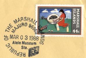
1. Republic of the Marshall Islands (vedi
in questa pagina cartoline SQL ed annulli)
2. Federated States of Micronesia ( vedi in questa
pagina un annullo)
3. Republic of Palau ( vedi in questa
pagina due pre-cancel ed una cartolina)
There
are no remaining islands in dispute between the USA and other
nations--only
some disputed wet boundaries between US lands and other nations.
None
of the US military, naval, or air bases in other countries (including
Guantanamo
(vedi annullo e cover a fondo pagina) in Cuba and those in the "freely associated states") are sovereign US territory.
Such US bases are sovereign territories of the host governments, let out
to US use under various kinds of lease agreements. Typically, the US has jurisdiction
over its people within these bases under the terms of the
agreements.
A
lease agreement for Guantanamo (leggere anche in fondo
pagina) in Cuba dates from 1903, and a 1934 treaty gave the
US a lease until we choose to abandon it. Every July, the US government sends
Cuba a check for the annual lease payment. Since the communist dictator Fidel
Castro seized power there in 1959, he has chosen to cash only one of the checks.
He would prefer to have the Americans out, but that's not likely to happen.
The money from the uncashed checks will be available to whatever government
Cuba has after Castro is gone.
OTHER
ISLANDS STILL UNDER DISPUTED UNITED STATES' SOVEREIGNTY
The United States' claim to Serranilla Bank: (vedi
Serrana bank in questa pagina)
About two hundred ten miles north north-east of Nicaragua lies the Serranilla
Bank. Some consider that the United States acquired the bank under the Guano
Islands Act of August 18, 1856 (Title 48, U.S. Code, sections 1411-19). Several
very small cays emerge above the water to form the bank's islands.
Colombia has not directly claimed Serranilla Bank, but is on record as
considering the bank a part of the Providence Archipelago in the intendancy of
San Andres y Providencia. Honduras may have asserted its own claim over
Serranilla as well.
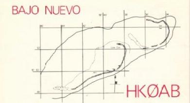
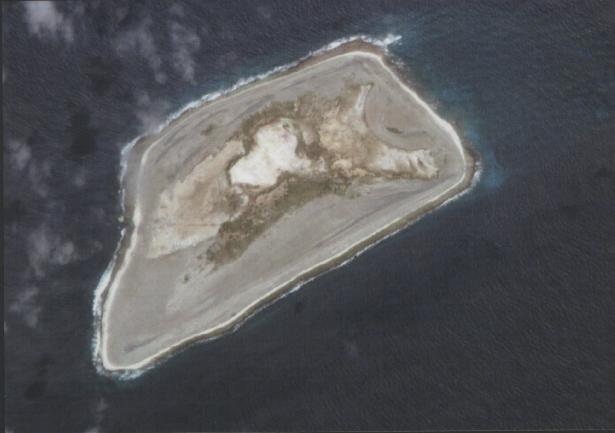
The United States' claim to Bajo Nuevo Bank: (qui Bajo Nuevo map):
Bajo Nuevo QSL del 1980 spedizione colombiana
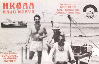
QSL card di spedizione a Bajo Nuevo
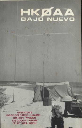
ho quest' altra QSL card del 1971
Gli Stati Uniti dovrebbero avere chiuso la disputa con la Colombia su Bajo Nuevo nel 1982.
Bajo Nuevo così fa parte delle isole colombiane del gruppo di San Andres e Providencia.
Essendo però vicina alla Giamaica il contenzioso potrebbe ancora sussistere.
Bajo
Nuevo che è un reef con isolette è noto anche con il nome di Petrel
islands e fu acquisito dagli USA nel 1856 con il Guano Act.
Inoltre
gli Stati Uniti ebbero il possesso dell'isola di Swan (vedi
in questa pagina una postcard SQL)
_______
list of acquisition processes of
islands:
http://www.doi.gov/oia/Islandpages/acquisition_process.htm
Descritpions of various US island possessions:
4 sono le modalità di annessione di isola:
http://www.doi.gov/oia/Firstpginfo/islandfactsheet.htm
List of past US disputes involving islands:
http://www.doi.gov/oia/Islandpages/disputedpage.htm
In the twentieth century the United States has disputed with other nations the status of certain islands
or atolls. Five (5) were in the Caribbean; twenty-five (25), in the Pacific. For purposes of discussion,
one may divide these thirty (30) islands or atolls into seven groups.
N.B. nell link soprascritto c'è indicato come si sono risolte tutte queste dispute.
L'applicazione della costituzione americana alle aree insulari degli USA è leggibile in questo file PDF in inglese.
http://www.gao.gov/archive/1998/og98005.pdf (ci sono anche diverse cartine geografiche)
Iniziamo ora a mostrare reperti filatelici o cartoline da collezione:
Due isole del GUANO ACT:
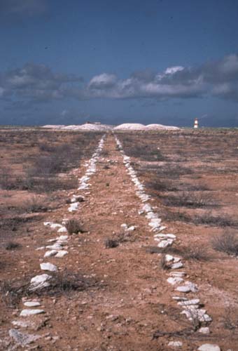
Jarvis island è un'isola praticamente disabitata di cui si avevano pochissimi reperti, sia fotografici che postali.
Nel tempo siamo riusciti a trovare pezzi molto interessanti :
2009: postcard di Jarvis island.
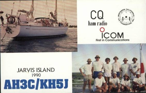
isola di Jarvis QSL del 1990
Ecco ora una cover in partenza da Jarvis quando nel 1957 era stato progettata la creazione di una stazione di ricerca:
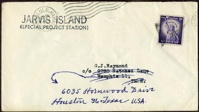
Jarvis* island (Special project Station) annullo di Honolulu 1957
Jarvis Island (also formerly known as Bunker Island) is an uninhabited 4.5 square kilometer coral island located in the South Pacific Ocean at 0°22′S 160°01′W / -0.367, -160.017Coordinates: 0°22′S 160°01′W / -0.367, -160.017 about halfway between Hawaii and the Cook Islands. It is an unincorporated territory of the United States administered by the United States Fish and Wildlife Service of the United States Department of the Interior as part of the National Wildlife Refuge system. Unlike most coral atolls, the lagoon on Jarvis is wholly dry. Jarvis is one of the southern Line Islands and for statistical purposes is also grouped as one of the United States Minor Outlying Islands. Jarvis was visited by scientists during the International Geophysical Year from July 1957 to November 1958. The island was then abandoned again. Any scattered building ruins remaining from both the 19th century guano diggings and the 1935-1942 colonization attempt were swept away without a trace by a severe storm, witnessed by the scientists, and lasting several days in January 1958. By the early 1960s a few sheds, a century of trash, the scientists' house from the late 1950s and a very solid, short lighthouse built two decades before were the only signs of human habitation on Jarvis.
Jarvis*: guano tramway, suppongo negli anni 1935-1942
Ecco ora una bellissima cover spedita nel 1951 ed indirizzata al postmaster di Jarvis island. Non essendoci un post office, la lettera fu ritornata al mittente via il P.O. di Canton island (una delle isole più vicine):
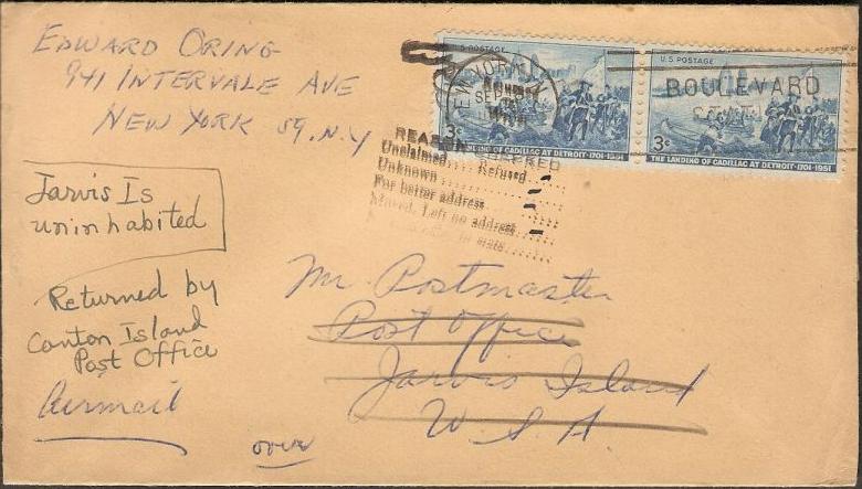
Jarvis island: lettera restituita al mittente. Da notare le scritte "isola non abitata", "ritorno via Canton island P.O."
ecco il retro della cover con uno splendido annullo di Canton island nel gruppo delle Phoenix:
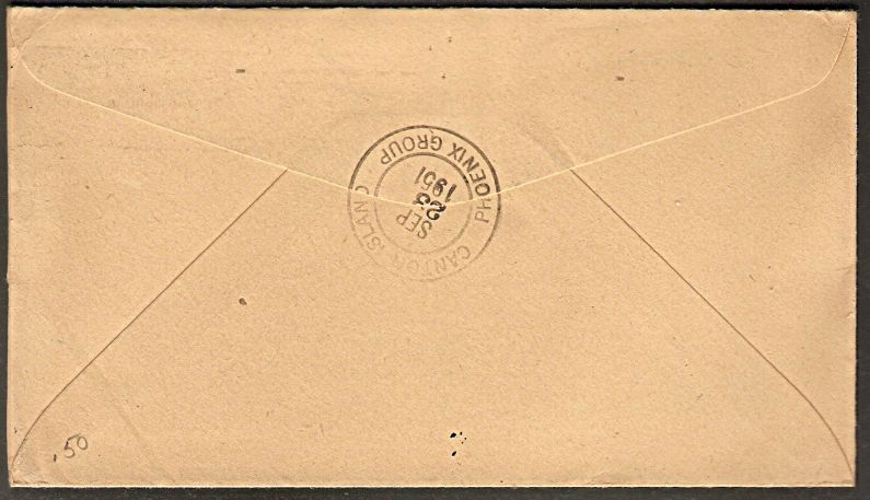
bell'annullo di ritorno via Canton island gruppo Phoenix
NOVITA'
![]() Ecco un'altra cover di
qualche anno più tardi: il 1960.
Ecco un'altra cover di
qualche anno più tardi: il 1960.
Questa cover ha avuto un tentativo di inoltro tramite Christmas island ed ha ricevuto l'annullo di Honolulu:
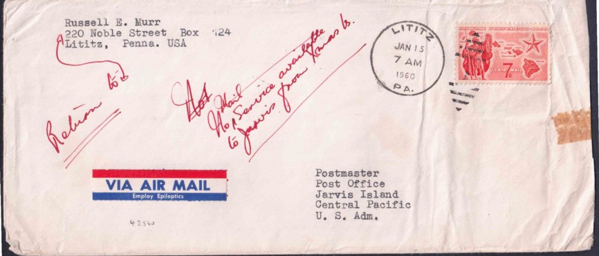
cover istradata verso Christmas island e poi rispedita al mittente RTS

annullo di Honolulu sul retro dove è transitata all'andata o al ritorno
Kingman reef: QSL del 1998
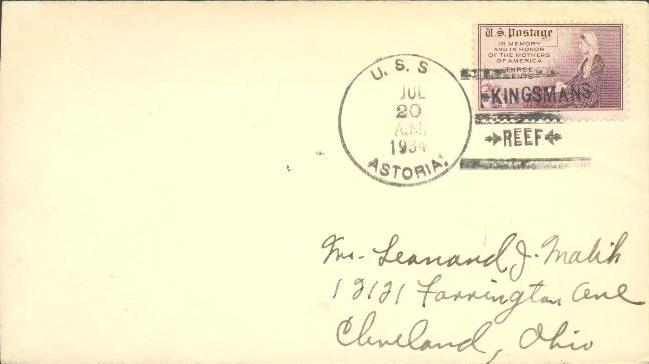
1934 cover dalla USS Astoria con raro annullo di Kingsmans reef
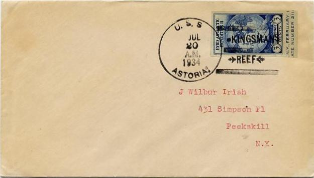
annullo di Kingsmans Reef sempre del 20 July 1934*
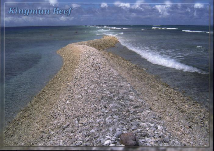
una postcard del 2007 tratta da una foto di C. Veley: Kingman reef
Passiamo ora all'isola di Guam:
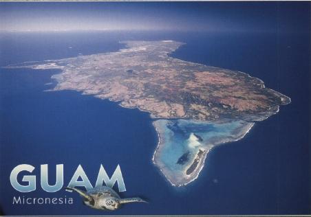
isola di Guam
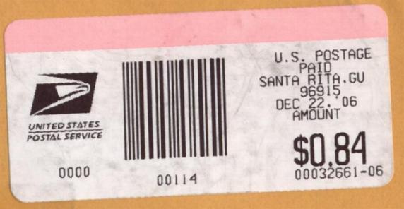
ufficio periferico di santa Rita a Guam, riaperto dopo la chiusura dell'agosto 2004
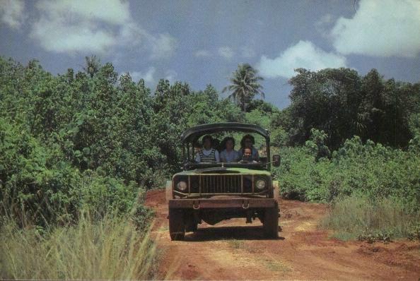
interno dell'isola di Guam
esistono francobolli degli USA sovrastampati Guam, abbastanza facili da reperire. Qui vediamo un annullo del 1937:
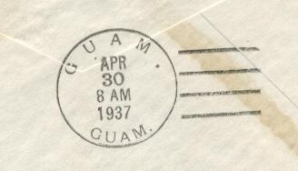
annullo di Guam 30 aprile 1937
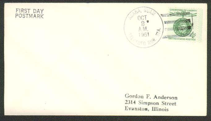
qui una bella cover del 1961 con lo scarso annullo rurale di Talofofo Guam
Grazie a Maurizio ecco ora un annullo dell'isola di Wake. Vedi altre informazioni al link: http://www.pacificwrecks.com/provinces/wake.html e al http://www.janeresture.com/wake/
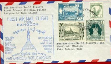
cover dalla Birmania a Wake island: primo volo da Rangoon della Pan Am.
L'isola di Wake si trova fra le Midway e Guam
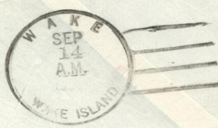
annullo di arrivo a Wake island
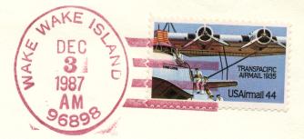
Wake island annullo del 1987 zip code 96898 degli USA
The US annexed Wake Island in 1899 for a cable station. An important air and naval base was constructed in 1940-41. In December 1941, the island was captured by the Japanese and held until the end of World War II. In subsequent years, Wake was developed as a stopover and refueling site for military and commercial aircraft transiting the Pacific. Since 1974, the island's airstrip has been used by the US military and some commercial cargo planes, as well as for emergency landings. There are over 700 landings a year on the island.
L'isola di Wake (19°' N e 166° E) è usata da lungo tempo come scalo per i voli transoceanici, accanto ad essa la più piccola isola di Wilkes, sempre statunitense. Attualmente è rivendicata dalle isole Marshall.
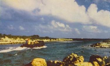
il canale che separa l'isola di Wake da quella di Wilkes
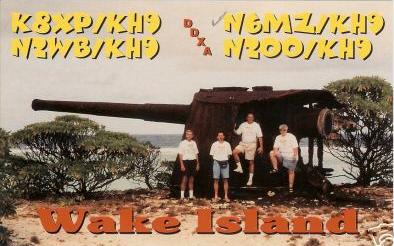
scarsa QSL card del 1998 di Wake* island
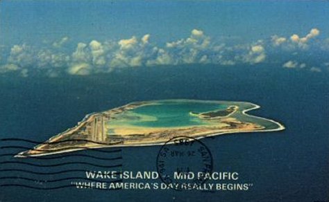
Wake* atoll
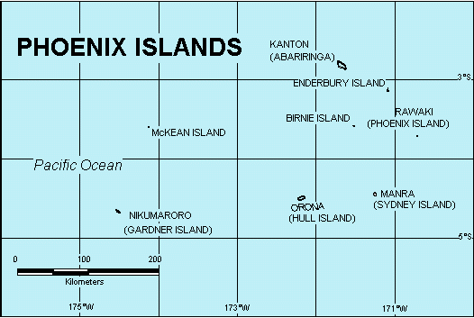
Anche l'isola di Canton (o Kanton) nel gruppo delle Phoenix (attualmente appartenenti alla repubblica di Kiribati), fu usata sin dal 1939 per i voli della PANAM. Vedi questa cover del 1941, con annulli su bolli americani:
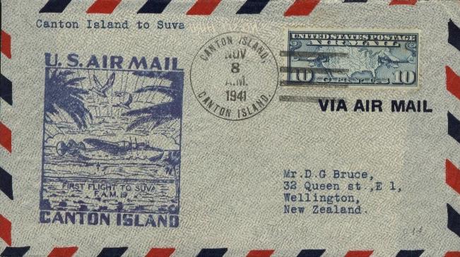
primo volo dall'isola di Canton a Suva nelle isole Figi 8 novembre 1941
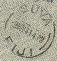
Suva capitale delle Figi: annullo d'arrivo sul retro
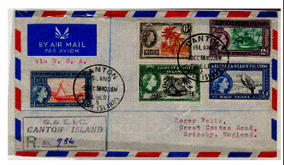
Canton island 1958 quando usava dentelli di Gilbert&Ellice (poi Kiribati)
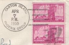
annullo del 1955 su bolli USA di Canton Phoenix group
Altre informazioni sull'isola di Canton (ex Mary's island), oggi non più statunitense, ma della repubblica di Kiribati( Central Kiribati, con il nome di Abariringa) al link: http://www.janeresture.com/kiribati_phoenix_group/canton.htm
dove ci sono altre cover interessanti. Idem vedi pagina 132 per una QSL. Comunque ecco una cartina che fa vedere l'isola di Canton o Kanton fra le Phoenix island del Pacifico a 3 gradi Sud di latitudine e 172 gradi di longitudine Ovest:
Un'isola che fu presa in carico dagli Stati Uniti in base al GUANO ACT fu l'isola di Navassa. Ora è territorio statunitense a tutti gli effetti, ma è rivendicata da Haiti. C'è un faro, per il resto è desolata e disabitata. Che io sappia non ci sono mai stati né annulli né molte cartoline panoramiche. Ho trovato su e-Bay un paio di lotti con cartoline QSL.
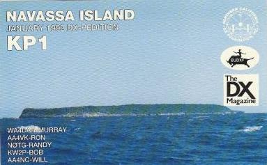
fronte di cartolina QSL di Navassa del 1992*
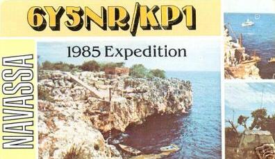
cartolina QSL di Navassa del 1985
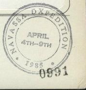
ecco un timbro della spedizione del 1985
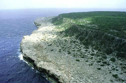
Riccardo ha mandato questa splendida immagine di Navassa di cui è possibile avere la postcard
Non poteva mancare un set di etichette, non perforate, di "posta locale" di Navassa island, apparso in USA nel 2007, ecco l'esemplare da 1 $:
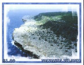
Navassa island L.P. del 2007
As
a guano island, Navassa (Navasha) entered the territorial domain of the United States
under contingent circumstances, and it is currently the only public land
administered by the Interior Department that is also claimed by a foreign nation
(Haiti). The following note outlines the legal history of the island and the
U.S. claim. Leggete la storia al link: http://members.aol.com/davidpb4/legal.html
Ma siccome Navassa island è stata in disputa con Haiti, ecco questa bella QSL card di un gruppo di Haitiani che nel 1981 hanno fatto una spedizione lì:
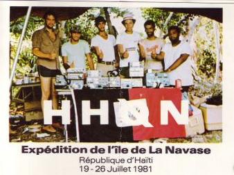
ile de La Navasse - Rep. d'Haiti QSL 1981
Un'altra isola USA è nel Pacifico, l'isola di Howland:
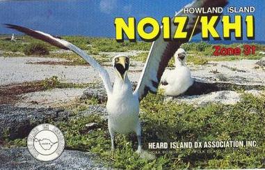
Howland island QSL card scarsa e costosa
Vedi una rara cartolina di Howland a pagina 132.
Quest'isola fu visitata nel 1988 da una spedizione che fece tappa anche su Baker island ( vedi pagina 3 ). Di Howland island abbiamo parlato quando abbiamo mostrato due annulli per Amelia Earhart a pagina 64, che scomparve nel 1937 in prossimità di quest'isola che appartiene agli USA. Vedi il faro che porta il nome della famosa aviatrice.
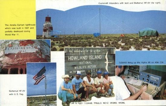
retro della QSL card, con immagine del faro con targa per Amelia Earhart
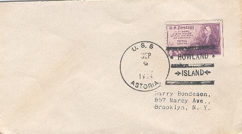
nel 1934 la nave U.S.S. Astoria passò di fronte ad Howland ed usò uno specifico annullo
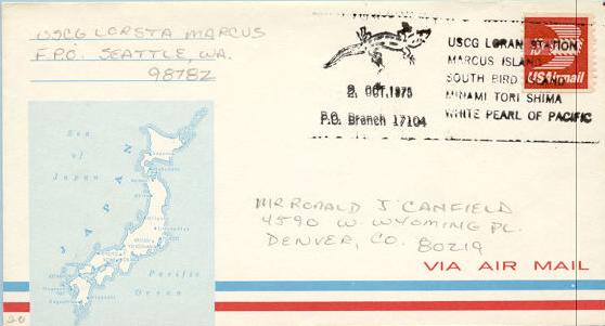
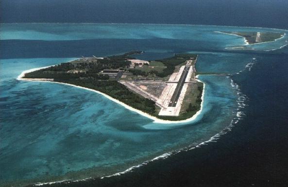
Un altra isola estrema è la MARCUS island. Si tratta di un'isola posseduta dal Giappone, ma c'è una base per le navi guardacoste (Loran Station) degli Stati Uniti ed esse dal dicembre 1970 al 1973 usavano l'annullo sotto riportato. Sino al 1945 Marcus island usava il Navy No. 3084 ed il navy P.O. 13808 BR. Comunque ora vi posso far vedere il navy FPO 98782 Marcus del 1980. Dal 1993 la base per guardacoste non c'è più.
![]()
Marcus Minami Torishima
cover di Marcus island amministrata oggi dal Giappone
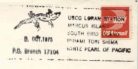
ecco l'annullo multiplo: "USCG Loran Station, Marcus island, South bird island, Minami Tori Shima
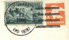
1980 Marcus island Coast Guard FPO 98782
Grazie alla e-mail dell'amico giapponese Henry H. esperto viaggiatore, ecco come avvengono le spedizioni della posta da parte del Giappone.
L'isola di Minami Torishima (Marcus island) è priva di ufficio postale per cui:
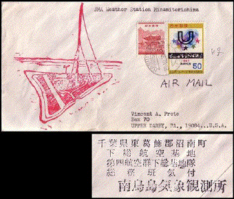
vediamo una cover del 1970 della stazione meteorologica giapponese, che fu inoltrata per l'annullo, alla base Shimousa Air Base of the Japanese Defense Forces.
Fabio,
That is an excellent cover from Marcus. Since it is a post-WW II, cover it
is also in my genre of interest. It is also a coast guard
operated station, the LORAN navigational station, which uses US stamps for mail
in a foreign country which is unusual. Normally
these covers are from US Army or Navy bases. This is indeed a very
interesting cover.
One Japanese source I found listed the closing of the LORAN station as ocurring
in 1993. So US stamp covers should have been possible
until then. There is no evidence that the island ever had a Japanese post
office. The island had a civilian settlement from
1896 to 1934 when it was abandoned due to economic non viability. Here is a
Japanese language site with detailed history:
http://www.passion-web.com/passion/torishima12.html
Here
is a cover from Marcus: http://topofswan.tea-nifty.com/hyper_philatelist_annex/cat1450614/
Scroll down to the entry for November 27, 2004. That cover was mailed from
Marcus. But since the island has no PO, mail is flown
by regular flight to the mainland and posted at the PO of the base. In this
case, it as a Kashiwa, Shiba cancel which means that mail at
the time was probably flown to Shimousa Air Base of the Japanese Defense Forces.
It has a Marcus cache with the return address from
the Japanese Meteorological Agency weather station and is probably the most
visible Japanese Marcus cover anyone will find. Cancel is
from 1970.6.27.
Cheers, HH
SE volete vedere altre cover di Marcus island, Minami Torishima andate a pagina 100c. English readers go to page 100c for other stuff of Marcus island.
Ed eccoci alle famose isole Midway:
cartolina dell'isola di Midway
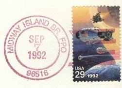
annullo FPO del 1992 su francobollo USA di Midway
Federazione della Micronesia FSM (altre informazioni al: http://www.postmark-micronesia.pwp.blueyonder.co.uk/federate.htm ):
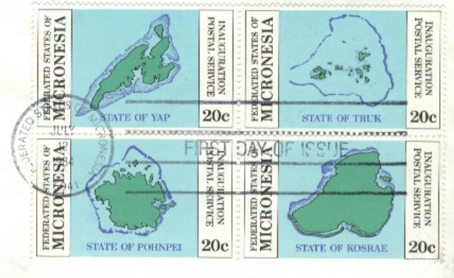
annullo su dentelli della Fed. di Micronesia: su bolli che rappresentano l'isola di Yap, Pohnpei, Truk e Kosrae
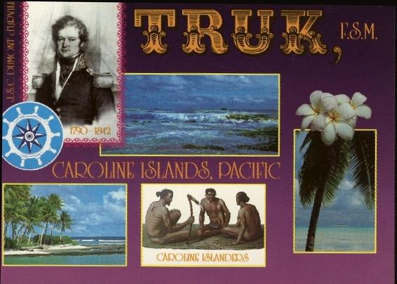
isole di Truk della Feder. degli Stati della Micronesia o isole Caroline
Palau islands (altre informazioni al sito http://www.postmark-micronesia.pwp.blueyonder.co.uk/palau.htm ):
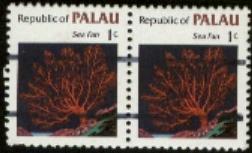
precancel di Koror su USA RP e poi su Repubblica Palau
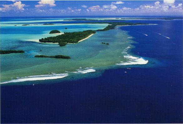
splendida cartolina delle isole Palau, repubblica del Pacifico
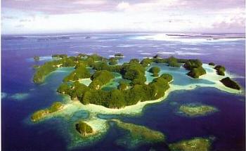
le rock islands di Palau
Marshall islands, (altre informazioni al http://www.postmark-micronesia.pwp.blueyonder.co.uk/marshall.htm ) ora repubblica, fra i suoi atolli, c'è quello di Enewetok, dove furono fatti i test atomici:
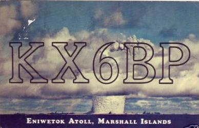
atollo di Enewetok, isole Marshall, sino al 1959 usato per test atomici *
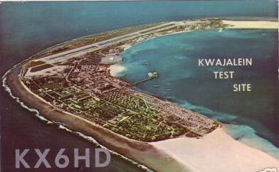
atollo di Kwajalein, isole Marshall, QSL postcard *
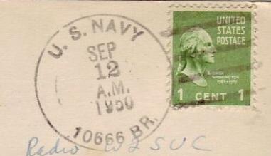
Kwajalein U.S: Navy 10666 BR *
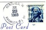
Kwajalein Honolulu Hawaii *
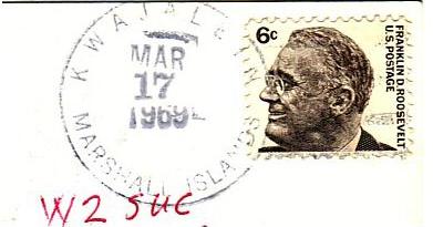
Kwajalein Marshall islands *
Marshall islands cancellation 1988*
Vale la pena mettere qui anche qualche QSL di isole/isolotti che erano o sono ancora in disputa:
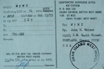
Per esempio l'isola di Swan era un "possession" statunitense dal 1863 per il solito guano act, poi nel 1972 fu riconosciuta la sovranità dell'Honduras. Prima di allora ci fu una stazione radio (1961) e esistono anche pseudo francobolli dell'isola di Swan:
QSL di radio Americas a Swan island * nelle West Indies
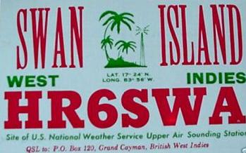
QSL Swan island *
timbro amministrativo di Swan island *
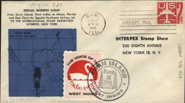
ecco una rara busta Swan/Miami/New York con annullo Miami, ma anche con l'etichetta della radio Swan island 1961
The United States' former sovereignty over
the Swan Islands:
In relative isolation, the Swan Islands lie in the western Caribbean,
ninety-five miles north of the coast of Honduras and three hundred twenty miles
west of Jamaica. They consist of Great Swan and Little Swan Islands, of which
neither has any dimension of more than about two miles. In 1863 the area was
certified as islands appertaining to the United States under the Guano Islands
Act of August 18, 1856 (Title 48, U.S. Code, sections 1411-19), and guano
operations were carried on there for many years.
The United States' later interests in the Swan Islands involved agricultural
production in coconut plantations and aids to navigation and communications,
resulting in continued United States occupation and use of the islands. In San
Pedro Sula, Honduras, on November 22,1971, American and Honduran representatives
signed a treaty by which the United States recognized Honduras' long-standing
claim to sovereignty over the Swan Islands. The treaty entered into force on
September 1, 1972.
Novità: ecco ora una cover, secondo me molto bella. Si tratta di una cover partita nel 1946 da Swan island, indirizzata a Staten island - New York, ed annullata a Tampa in Florida:
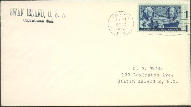
notate la scritta SWAN island USA Carribbean Sea: 1946 annulo di Tampa
ma l'Honduras riconferma i propri diritti su Swan island: ecco una QSL* del 2000
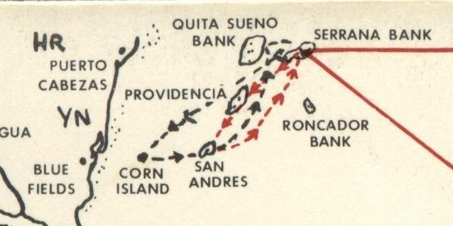
Un'altra zona di dispute è quello della zona atlantica della Colombia, in faccia al Nicaragua.
Ivi ci sono Roncador Cay, Serrana Bank, and Serranilla Bank. C'è ancora disputa fra Honduras, Nicaragua e Colombia. Vedi anche il link: http://www.425dxn.org/dc3mf/serra1e.html
Un tempo anche gli USA avanzavano diritti su Serrana bank e Serranilla:
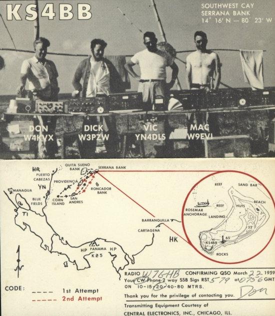
QSL di spedizione del 1959 a Serrana Bank
La spedizione ebbe diverse difficoltà a scendere a Serrana Bank, leggete qui le vicissitudini:
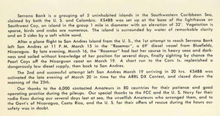
Se notate il percorso della spedizione nella mappa qui sotto, vedrete che Serrana Bank si trova in faccia al Nicaragua (all'altezza di Bluefields), vicino alle isole colombiane di San Andres e Providencia (isola del pirata Morgan) e l'isola di Corn island (Nicaragua) di cui abbiamo già parlato in questo sito o di cui parleremo fra poco! Vedremo di procurarci anche qualche cosa relativamente a Quita Sueno Bank e Roncador Bank!
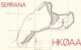
Serrana bank map QSL 1980
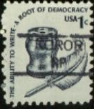
PortoRico Stato Associato agli USA:
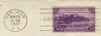
annullo di San Juan di PortoRico 1937
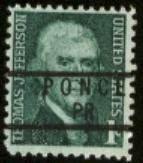
PortoRico pre-cancel di Ponce
Commonwealth delle Marianne del Nord:
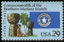
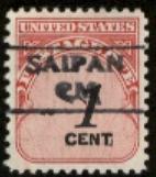
Nord Marianna commemorativo e pre-cancel di Saipan
QSL Northern Mariana islands, Saipan USA 1991
Altra lista da controllare:
i primi 13 nomi sono Ok e abbiamo i reperti filatelici!
Here's my own list of US
territories:
U.S. Insular Areas:
1. American Samoa (Pago Pago)
2. Baker Island and Howland Island
3. Commonwealth of the Northern Mariana Islands
(Saipan)
4. Guam (Agana/Hagåtña)
5. Jarvis Island
6. Johnson Atoll
7. Kingman Reef
8. Midway Islands
9. Navassa Island
10. Palmyra Atoll
11. Puerto Rico (San Juan)
12. U.S. Virgin Islands (Charlotte Amalie)
13. Wake Island
Formerly Disputed Islands: (queste dispute
in parte si sono già risolte, ma è bello cercare reperti quando esse erano in
atto),
vedi dettagli a questo link: http://www.doi.gov/oia/Islandpages/disputedmain.htm
NOVITA':
ho fatto una pagina specifica per le EX DISPUTE: vedi pagina
109. Contiene informazioni su tutte le isole sotto elencate:
(1) Canton (vedi una cover in questa pagina),
Enderbury, Hull, Birnie, Gardner, Phoenix,
Sydney, McKean, Christmas, Caroline, Starbuck, Malden,
Flint and Vostok (to Kiribati)
(2) Danger, Manahiki, Penrhyn and Rakahanga (to the Cook Islands)
(3) Atafu, Fafaofu and Nukunono (to Tokelau)
(4) Funafuti, Nukefetau and Nurakita (to Tuvalu)
(5) Quita Sueno Bank, Roncador Cay and Serrana Bank
(to Colombia) (vedi QSL postcard in
questa pagina)
(6) Swan Islands (to Honduras)
(vedi QSL postcard in questa pagina)
(7)
Corn Islands (to Nicaragua)
vedi qui una cartolina ed una cover particolare, su cui ritorneremo raccontandone la storia:
Corn islands sono sono due isole in faccia al Nicaragua sulla costa atlantica: Corn island e Piccola Con island. Esse non furono mai un territorio posseduto dagli Stati Uniti, bensì un "territorio "leased" o noleggiato". L'accordo cessò nel 1971.
Ad inizio 1900 i collegamenti da e per le isole erano estremamente difficili, anche perché la strada sulla costa del Nicaragua, verso la capitale, si addentrava in acquitrini malsani ed in foreste.
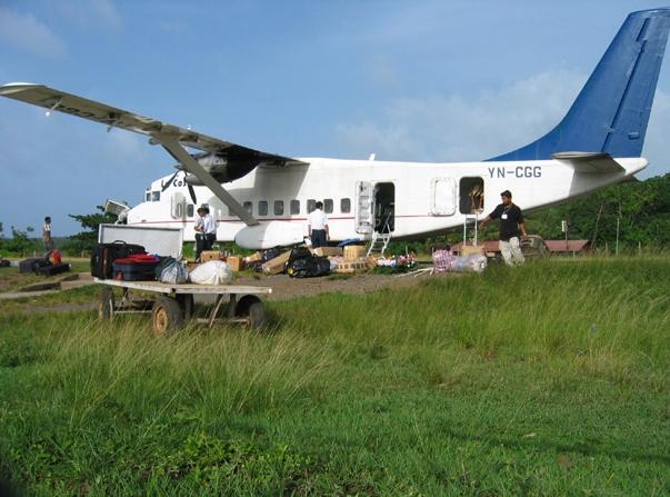
rifornimenti a Corn island (Nicaragua)
Corn island Nicaragua in una QSL card. Le 2 Corn islands sono state ribattezzate Islas del Maiz
Little Corn island in una QSL del 2003, ora è una delle isole del Maiz
dal punto di vista filatelico è interessante esaminare questa cover d'epoca:
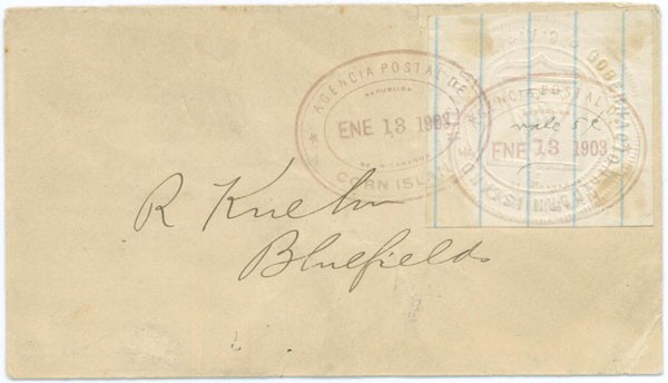
Corn island 1903 cover con francobollo locale falso
Questa
bellissima cover comprata per pochi dollari, (una analoga fu venduta anni fa ad
un asta ad alto prezzo), è in realtà un falso da me scoperto confrontando la
calligrafia ed i nome sull'indirizzo con
le false lettere di Mosquito Coast fatte dallo stesso falsario. Qui si suppone
che la mancanza di francobolli e data la difficoltà di approvvigionamento,
abbia costretto il postmaster ad emettere rozzi francobolli locali, imprimendo
un timbro su carta da quaderno, con aggiunta di un annullo ovale con scritto
"Agencia Postal del Corn island" "13 gennaio 1903".
Monterò il link ad un mio articolo in inglese, sia su questo bollo che sui più
famosi e rari bolli di Mosquito Coast. Ma per ora leggete una parte della
storia a pagina 83 dove riprendo quest'isola
e questa cover.
Other territories:
- Guantanamo Bay Naval Station (leased territory) (vedi
annullo in questa pagina)
-United States Antarctica
Amudsen-Scott, Mc Murdo vedi annullo
e card a pagina46a, e Palmer)
-Serranilla Bank
(also claimed by Colombia and Honduras)
-Bajo Nuevo Bank (also claimed by Jamaica and Colombia) dette anche PETREL
islands
-Machias Seal Island (also claimed by Canada)(vedi immagini appena sotto):
Machias Seal Island is a treeless 10 acre rock / bird sanctuary located in the Bay of Fundy approximately 18 kilometers south west of Grand Manan Island. An island claimed by both Canada and the United States, Canadians have maintained a light station there since 1832. Today two lightkeepers man the station for 28 day shifts. When their stint is finished two more keepers replace them for the next 28 days. Change-over is made by a Canadian Coast Guard helicopter.
Una rapida traduzione dice: l'isola di Machias o Seal island è un santuario per gli uccelli, ma è privo di alberi ed è di piccole dimensioni: non più di 10 acri di terreno. Machias è situata nella baia di Fundy a 18 km circa a sud ovest della Grand Manan island. Quest'isola è disputata da USA e Canada che ne rivendicano l'appartenenza al loro Stato. I Canadesi mantengono un faro sull'isola sin dal 1832. Ai nostri giorni, due uomini provvedono al mantenimento del faro per 28 giorni di seguito, dopodiché sono sostituiti da altre due persone. Il cambio viene effettuato tramite un elicottero della Guardia Costiera.
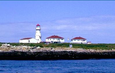
Machias seal island è un santuario degli uccelli. L'isola è contesa fra USA e Canada
Quest'isola non si deve confondere con una che sembra omonima, ma non lo è: e cioè Seal island che una piccola isola del Penguin group islands, che sta in Namibia nella Walvis Bay: (vedi altre iinformazioni su Penguin island info cliccando QUI):
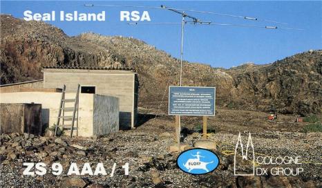
Seal island quando era del Sudafrica RSA in una QSL card del 1990
U.S. Exclaves ('in' Canada):
-Northwest Angle, Minnesota
-Point Roberts, Washington
-Estcourt, Maine
-Hyder, Alaska
Dettagli su Guantanamo: territorio cubano in affitto agli U.S. :
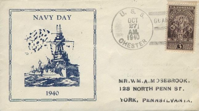
annullo di Guantanamo Bay
Guantanamo Bay*
ecco una bella QSL con Guantanamo Bay*
già che parliamo di Cuba ecco un "Cuban water" postmark
The U.S. Navy Public Affairs Office
there has a website.
A couple of items were new and of interest (at least to me): 1) the US had two leased territories in Cuba and (2), the U.S. considers that
while it occupies the bay, Cuban sovereignty has ceased and that it is U.S. territory" subservient to U.S. legislation. That goes against
the contentions of the Department of Defense which holds Al Kaida prisoners without access to U.S. justice because it isn't "US
territory". The government is trying to have it both ways.
Quotes below:
"The first lease agreement... was signed by President Estrada Palma on 16 February 1903, and by President Theodore Roosevelt on 23 February
1903. By this instrument Cuba leased to the United States certain areas of land and water in Guantanamo and Bahia Honda for the purpose
of "coaling and naval stations". (Bahia Honda was abandoned after nine
years of occupation). Concerning Guantanamo, the agreement describes
the leased "areas of land and water" as follows:
"In Guantanamo (see Hydrographic Office Chart 1857), from a point on the South Coast, 4.37 miles to the eastward of Windward Point Light
House, a line running north (true) a distance of 4.25 nautical miles; from the northern extremity of this line, a line running west (true),
a distance of 5.87 nautical miles; from the western extremity of this last line, a line running south-west (true), 3.31 nautical miles; from
the southwestern extremity of this last line, a line running south (true) to the seacoast".
The land area above described comprises 19,621 acres, 11,058 on the windward side, and 8,563 on the leeward. The water areas, consisting
principally of Guantanamo Bay from the mouth of the harbor (theoretical line joining Leeward and Windward Points) to the northern
boundary line, comprise 9,196 acres. The total naval reservation contains 28,817 acres or about 45 square miles of land and water. (The
foregoing figures are based on the original survey).
Furthermore, the agreement granted the United States the right to use and occupy the waters adjacent to the above described areas of land
and water. "Adjacent waters" are interpreted to mean the water leading
up to the harbor entrance and the water along the seacoast out to the
three mile limit. The United States has the right to improve and deepen the entrances to the leased areas of land and water, and to
improve and deepen the anchorages therein, and generally to do. any and all things to fit the premises as a coaling and naval station, and
for no other purpose.
Over the leased areas of land and water, comprising the Naval reservation, Cuba consented that during the period of occupation, the
United States would exercise "complete jurisdiction and control over and within said areas", including the right to acquire for the public
purposes of the United States any land or property therein by purchase or by right of eminent domain with full compensation to the owners
thereof. On the other hand, the United States recognized "the continuance of the ultimate sovereignty of Cuba over and above the
leased areas". "Ultimate", meaning final or eventual, is a key
word here. It is interpreted that Cuban sovereignty is interrupted during
the period of our occupancy, since we exercise complete jurisdiction and control, but in case occupation were terminated, the area would
revert to the ultimate sovereignty of Cuba.
Restrictions:
The only restrictions placed by this document on the United States are:
(a) The area must be used only for a coaling and naval station ("station" here used in the broad sense of the word.)
(b) Vessels engaged in Cuban trade shall have free passage through the waters included in the grant.
Pursuant to the agreement of February 1903, the Naval reservation was surveyed and marked out by a joint United States-Cuban Board
(Commission). The first meeting of this body took place on board the USS Olympia anchored in Guantanamo Bay on 27 May 1903, and the general
plans of the operations were agreed upon. On the next day the work of survey and marking out of the Naval Station was begun, and was
continued without interruption on working days until its termination on 8 July 1903.
In the years since this survey there has been occasional misunderstanding of what constitutes the water areas of the Naval
Reservation. There was no misunderstanding in the minds of the joint United States-Cuban body which made the above survey. Their thinking
was crystal-clear. The last part of their report, which must be considered ancillary to the original lease agreement, is quoted in
evidence on this point:
"G-Area of the Naval Station The area of water and land, obtained analytically, included within the
limits of the Naval Station, closing the perimeter across the entrance to the harbor by a line joining Leeward and Windward Points, was found
to be 11661.9832 hectares, equal to 28817.360 acres.
"To determine the proportion of land and water in the area, it would be necessary to survey the interior coast lines of the bay and the
Guantanamo River, a work which on account of its nature and extent, would have required about three months to do.
Surveying the land
"Considering that in the year 1899, the officers of the gunboat Eagle of the United States Navy were several months on the ground doing
precisely this work, together with soundings of the bay, and that the accuracy of their work was well checked by the present survey, the
notes and original plans of work were asked for and received from Washington. With these data, the interior coast lines of the
accompanying plan were plotted, using the same scale, 1 to 10,000, of the original plans. By planimeter measurements the following result
was obtained.
"Area of Land
Seven thousand nine hundred forty and 2832/10,000 hectares equals Nineteen thousand six hundred twenty and 848/1000 acres.
"Area of Water of Public Domain
Three thousand seven hundred twenty-one and 7000/10,000 hectares equal Nine thousand one hundred ninety-six and 512/1000 acres.
"Total Area of the Naval Station
Eleven thousand six hundred and sixty-one and 9832/10,000 hectares equals twenty-eight thousand eight hundred seventeen and 360/1000 acres".
The above report was signed for Cuba by José Primelles, Director General of Public Works, President of Cuban Commission, and by
Augustine Gordillo, Engineer in Charge; and for the United
States, by Captain H. W. Lyon, Senior Member of the U. S. Board, and by LCDR
Warren McLean and LT H. K. Benham, all of the U.S. Navy. The place and date of signature was on board the "U. S. Flagship Olympia" in
Guantanamo Bay, 8 July 1903.
Supplementary Agreement
In the meantime, a supplementary agreement concerning the Naval reservation had been reached between the United States and Cuba. This
agreement which was signed at Havana on 2 July 1903, and approved by President Theodore Roosevelt on 2 October 1903, is appended for
reference. The salient points of this agreement are as follows:
(a) The United States contracted to pay Cuba the annual sum of two thousand dollars in gold.
(b) All private lands or other real property were to be acquired by Cuba with funds to be provided by the United States, such funds to be
accepted as advance payment on the annual rental of $2000. (This clause was obviously for the purpose of acquiring land and property
from property owners in order that Cuba could lease the area with no private
encumbrances).
(c) The areas were to be surveyed and the boundaries distinctly marked by permanent fences or enclosures-the United States to bear the
expense of construction and maintenance of such fences or enclosures.
(d) The Unites States agreed that no person, partnership, or corporation would be permitted to establish a commercial, industrial,
or other enterprise within the reservation.
(e) It was agreed that fugitives from justice charged with crimes and misdemeanors amenable to Cuban law, taking refuge in the reservation,
should be delivered to Cuban authorities, on demand; and likewise that fugitives from justice charged with crimes or misdemeanors amenable to
United States law, committed within the reservation, taking refuge in Cuban territory, should be delivered on demand.
(f) It was agreed that materials of all kinds, merchandise, stores, and munitions of war imported into the reservation, for exclusive use
and consumption therein, should not be subject to payment of customs duties nor any other fees or charges, and the vessels which might
carry the same would not be subject to payment of port, tonnage, anchorage, or other fees. This in effect, made Guantanamo Bay a
"duty-free port". It was further agreed, however, that such materials,
merchandise, stores, and munitions of war should not be transported
from the reservation into Cuban territory.
(g) The United States agreed, except in case of war, to place no obstacle in the way of vessels entering or departing from Guantanamo
Bay en route to or from Cuban ports (e.g., Caimanera); such vessels within the limits of Cuban territory to be subject exclusively to
Cuban laws and authorities.
Treaty of 1934
In all provisions regarding the Guantanamo area, the original agreement (February 1903) and the supplementary agreement were later
confirmed by the Treaty of 1934 between the United States and Cuba, signed at Washington on 29 May 1934. A copy is appended for reference.
This treaty has the effect of giving the United States a perpetual lease on this reservation, capable of being voided only by our
abandoning the area or by mutual agreement between the two countries. The so-called "Platt Amendment," which gave the United States the
right to intervene in Cuba, died with this treaty. Bahia Honda was not mentioned, having long since been abandoned.
Thus it is clear that at Guantanamo Bay we have a Naval reservation which, for all practical purposes, is American territory. Under the
foregoing agreements, the United States has for approximately fifty years exercised the essential elements of sovereignty over this
territory, without actually owning it. Unless we abandon the area or agree to a modification of the terms of our occupancy, we can continue
in the present status as long as we like. Persons on the reservation are amenable only to United States legislative enactments. There are a
few restrictions on our freedom of action, but they present no serious problem. We may not use the reservation for other than a naval
station; we have agreed not to interfere with the passage of vessels engaged in Cuban trade; private enterprise is forbidden on the
reservation; and we are obligated to prevent the smuggling of materials and merchandise into Cuban territory.
Images of GTMO in 1920sThe prosecution of Cuban Nationals and other aliens who commit crimes and misdemeanors on the reservation presents
a subject that should be mentioned. Until the advent of the Uniform Code of Military Justice on 31 May 1951, the United States has had no
peacetime legal machinery for trying such offenders. Accordingly, we have habitually requested local Cuban courts to exercise concurrent
jurisdiction and handle such cases. Because essential witnesses, usually U. S. military personnel, are oftentimes transferred before
offenders are brought to trial, this procedure has its shortcomings. However, it will likely be continued. In a reciprocal manner, U. S.
military personnel, charged with offenses in Cuba, are habitually turned over to U. S. jurisdiction for legal action.
Closed Port
While this chapter is designed to cover the terms of our lease, and what they mean in a legal sense, no outline of the reservation's legal
status would be complete and up-to-date without mention of the executive order which made Guantanamo Bay a "closed port". This order,
signed by the President on 1 May 1941 and currently found in General Order No. 13, establishes Guantanamo Bay as a "Naval Defensive Sea
Area" and a "Naval Air Space Reservation". By its terms no vessel
or other craft, other than public vessels of the United States and
vessels engaged in Cuban trade, may be navigated into the area, unless similarly
authorized, no aircraft, except other than public aircraft
of the United States, may be flown into the reservation. In other words, Guantanamo Bay is closed to commercial shipping and aircraft,
except vessels engaged in Cuban trade, and also to foreign warships and aircraft. Vessels and aircraft in distress can be the only
exceptions to this regulation."
MAURIZIO dà un notevole contributo, mandando una lista di posti che potrebbero avere degli annulli militari di tipo OPO o FPO.
Ecco cosa ha detto: "L'esercito americano ha operato un po' in tutto il mondo e ha sempre avuto al seguito i suoi uffici postali."
La lista di Maurizio è a pagina 69aa. Quindi la caccia alle cover di APO degli USA è aperta.
Qualora possibile sarebbe bello indicare vicino ad ogni
"locazione" il corrispondente APO o FPO, sempre che esista.
Per caso
sono capitato in un sito dove ho trovato l'elenco di tutti gli APO e FPO in
essere al 1990. Va esaminato, perché quello che ci interessa di più sono le
codifiche intorno alla seconda guerra mondiale.
Chi lo volesse esaminare vada al http://www.dtic.mil/whs/directives/corres/html/45256l1.htm
e si scarichi il file in PDF o in .text e mi dia il suo parere.
Ho trovato anche un sito che ha tutte le mappe di tutto il mondo o quasi. Ecco la parte relativa ai Territori Esterni degli Stati Uniti:
Fine di questa pagina: la 1a PARTE U.S.A continua a pagina69aa con gli APO e FPO, clicca QUI!
Invece la 2a PARTE prosegue a pagina
69a: clicca QUI
Invece la 3a PARTE prosegue a pagina 69b: clicca QUI
inoltre le basi Antartiche Britanniche sono a pagina 91 clicca QUI
La parte 4a con i TERRITORI ESTERNI di altre nazioni, quali l'Australia, Danimarca, Olanda, Nuova Zelanda e Portogallo, è a pagina 95 clicca QUI.
------------------- °°°°°°°°°°°°°° --------------------
Mi
scuso per eventuali imprecisioni, infatti, per risparmiare tempo,
mi sono affidato solo alla mia memoria. Per certo posso fornire le fonti -
sicuramente più attendibili di me - da cui ho tratto le varie informazioni.
Se volete approfondire i vari argomenti, contattatemi. P.S.
Su questo sito potete vedere immagini, articoli e approfondimenti
ai temi discussi nei miei messaggi per il forum Filatelia e Francobolli.
Chi
fosse interessato ai bolli della seconda guerra mondiale, a quelli dei
prigionieri di guerra o di propaganda psicologica, alla resistenza, nonché
alla storia contemporanea, incluse le missioni di pace italiane nel mondo e
quelle scientifiche al polo sud, può visitare le oltre 500 pagine, in italiano
ed in inglese, del sito, cliccando semplicemente sul tasto
"Iniziale" qui sotto. Gli
altri tasti aiutano la navigazione all'interno di questa sezione "le
storie dietro i francobolli" e "Curiosità filateliche". Precisamente:
il sommario riporta gli argomenti trattati in ogni pagina; i tasti dall' 1 al 96
aiutano ad accedere direttamente alle prime xx pagine (12 per volta) ed infine
c'è il link alla corrispondente pagina/pagine del Forum di F&F in cui
lo stesso "topic" è stato discusso. ![]() NOVITA': Se cercate uno specifico argomento ed il Sommario
non è esauriente, potete provare con il nostro motore di ricerca. Esso funziona
all'interno del sito, e può essere utilissimo. Basta scrivere la
parola che si cerca, nel rettangolo qui sotto e cliccare a destra su "find".
La ricerca può essere
fatta con una singola parola, con più parole ed anche con un * alla fine di una
parola se si vuole interrogare sia il singolare che il plurale di una parola.
Per esempio facendo la ricerca con la parola mission*
si cercano tutte le pagine del sito, che contengono le seguenti parole:
missione, missioni ed anche mission, e missions, etc. NOVITA'
NOVITA': Se cercate uno specifico argomento ed il Sommario
non è esauriente, potete provare con il nostro motore di ricerca. Esso funziona
all'interno del sito, e può essere utilissimo. Basta scrivere la
parola che si cerca, nel rettangolo qui sotto e cliccare a destra su "find".
La ricerca può essere
fatta con una singola parola, con più parole ed anche con un * alla fine di una
parola se si vuole interrogare sia il singolare che il plurale di una parola.
Per esempio facendo la ricerca con la parola mission*
si cercano tutte le pagine del sito, che contengono le seguenti parole:
missione, missioni ed anche mission, e missions, etc. NOVITA'
![]() QUI LA SEARCH ENGINE per ricerche all'interno di tutto il sito:
QUI LA SEARCH ENGINE per ricerche all'interno di tutto il sito:
N.B. Le schermate sono state ottimizzate per video a 17 pollici e collegamento ADSL, per cui molte righe ed immagini potrebbero risultare distorte, spostate o lente a scaricarsi, su altri schermi o computer con vecchi modem. Nel caso scrivetemi che provvederò a fare migliorie specifiche.
 |
 |
|
 |
 |
 NEW FORUM lafialtelia.it